You bought the house plans, picked a builder and filled out the application, and then the permit counter asks for one more sheet: the site plan. It is often the shortest drawing in the package and one of the most common reasons a residential permit gets held up. Below are the questions owners and builders ask most often about it, answered for how permitting works in most U.S. cities and counties.
Why does the county want a site plan if my house plans are already complete?
Because a stock plan set describes the house, while the site plan shows where that house goes on your specific lot. Floor plans, elevations, sections and framing details are the same whether the home is built in a cul-de-sac in Texas or on five acres in Ohio. Zoning setbacks, lot coverage, drainage, flood elevation, septic or sewer, and utility connections are unique to your parcel.
Zoning, the building department, public works and sometimes the health department all review this one sheet. A plan like this 2,150 sq ft two-story Modern Farmhouse with a 2-car garage will fit easily on a typical suburban lot, but the reviewer still needs to see the dimensions that prove it.
What is the difference between a site plan, a plot plan and a survey?
In everyday use, "site plan" and "plot plan" mean the same thing: a scaled drawing of your lot with the proposed house, driveway and improvements drawn on it. A survey is different. It is a legal document prepared and sealed by a licensed land surveyor, showing measured property lines, corners, easements and existing features.
Many site plans are drawn on top of a survey, which is why people mix the terms up. Some jurisdictions accept a site plan based on the recorded plat. Others require a sealed boundary survey, a topographic survey, or a "proposed plot plan" from a surveyor. Ask the permit office which one they need before you order anything.
Who is allowed to draw the site plan?
That depends on the jurisdiction. It can be a licensed surveyor, a civil engineer, a drafter or the owner. Many rural counties accept a neat, scaled owner-drawn sketch for a simple lot with a septic system. Many cities and fast-growing suburban counties require a surveyor or engineer, especially when grading, stormwater or flood zones are involved.
A practical rule: if your lot is flat, large and outside a flood zone, a drafter or careful owner can often do it. If the lot is tight, sloped, in an HOA subdivision with strict grading plans, or near water, budget for a professional. Owners who start from a sloped lot house plan almost always end up needing topographic data from a surveyor anyway.
What does a permit reviewer expect to see on it?
Most checklists ask for some version of the following:
- North arrow, scale (commonly 1 inch = 20 or 30 feet), address and parcel number
- Property lines with bearings or lengths, and the lot area
- Easements, rights-of-way and any recorded building lines
- The house footprint, including porches, decks, stoops and the garage
- Distances from the foundation to every property line
- Driveway, walks, patios and the impervious area total
- Existing and proposed grades or contours, and the finished floor elevation
- Drainage arrows and any swales, downspout outlets or stormwater features
- Sewer or septic system, well, water line, power, gas and communication routes
- Erosion control such as silt fence and a construction entrance, where required
How do I show setbacks correctly?
Dimension the shortest distance from each property line to the nearest part of the structure, and show the required setback next to it. Typical single-family zoning in 2025 might call for a front setback somewhere around 20 to 35 feet and side setbacks of 5 to 10 feet. Your zoning code and plat are the only numbers that count, and an HOA may add stricter ones.
The common trap is measuring to the wrong thing. Some codes measure to the foundation wall. Others measure to the eave, a covered porch, a bay window or chimney projection, with only limited encroachments allowed. On a narrow lot, a few inches of roof overhang can matter. With a compact design like this 1,616 sq ft two-story Craftsman with 3 bedrooms, show the porch and eaves clearly so the reviewer does not have to guess. The narrow lot collection is a good place to compare footprints before you commit.
Why do they care about impervious area and lot coverage?
Because roofs and pavement send rainwater onto neighbors and into storm systems, many jurisdictions cap how much of a lot can be covered or charge stormwater fees based on it. The roof, driveway, walks, patios and sometimes gravel all count. Put a small table on the site plan listing each surface in square feet and the total as a percentage of the lot.
Large one-story homes reach these limits fastest. A 4,038 sq ft single-story Ranch with a 3-car garage has a big roof and usually a wide driveway, so on a half-acre lot it may approach a coverage limit that a two-story house of the same size never would. Crossing a local threshold can trigger an engineered stormwater plan, so check the number early.


What is finished floor elevation and why does it go on the site plan?
Finished floor elevation (FFE) is the height of the main floor relative to a reference point, usually the street or a surveyed benchmark. Reviewers use it to confirm that the house sits high enough to drain away from the foundation, that the garage slab and driveway slopes work, and, in flood zones, that the floor meets the required elevation.
In a FEMA flood zone you will often need an elevation certificate, and the local floodplain ordinance may require the floor some distance above the base flood elevation. That is why coastal plans like this 2,955 sq ft four-story Florida-style home with 4 bedrooms raise the living areas off the ground. In the North and Midwest, a basement plan such as this 1,777 sq ft one-story farmhouse with a basement needs the FFE and the existing grades together, so the reviewer can see how deep the excavation goes and where the water will go.
How should I draw drainage arrows?
Draw arrows showing the direction surface water will flow, starting at the house and continuing to a street, swale, ditch or approved outlet, never into a neighbor's yard. The IRC requires the grade to fall at least 6 inches within the first 10 feet from the foundation, with alternatives such as swales where lot lines or walls are too close. Many reviewers want to see that slope noted or shown with spot elevations.
Show where downspouts discharge, any side-yard swales, and how runoff from the driveway is handled. In subdivisions with a master grading plan, the arrows must match the lot's assigned drainage pattern (often labeled front-draining, rear-draining or split). On hillside lots like the one this 4,571 sq ft Mountain Craftsman with a walkout basement is designed for, add contours, because arrows alone will not convince anyone.
How do I show septic, sewer, well and utilities?
Draw each line from its source to the house, and label it. On city lots, show the sewer lateral, the water service from the meter, power, gas and communications, along with the easements they cross. On rural lots, show the septic tank, the drain field and its reserve area, the well, and the distances between them and to the house, property lines and any water.
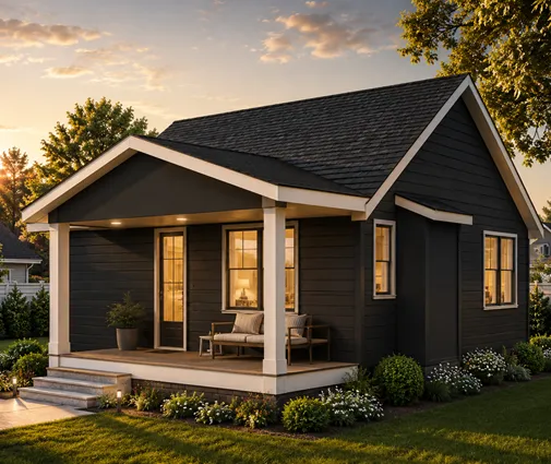
Separation distances between wells and septic systems are set by state and county health rules and often fall somewhere between 50 and 100 feet, but confirm with your health department, because a septic permit usually has to be approved before the building permit. Even a small home like this 750 sq ft two-bedroom cabin needs a full septic and well layout when it is off the grid.
What omissions most often get a site plan sent back?
The same few appear again and again:
- No scale or north arrow, or a drawing that is not actually to scale.
- Setbacks dimensioned to the wrong point, or missing for one side.
- Porches, decks, stoops, AC pads or retaining walls left off the footprint.
- Easements not shown, especially utility and drainage easements along rear lines.
- No impervious area calculation, or one that leaves out the driveway.
- No finished floor elevation, or no existing grades to compare it with.
- Drainage arrows that point toward a neighbor or ignore the subdivision grading plan.
- Septic, well or utility routes missing or without separation distances.
- No erosion control shown where the county requires it.
How much does a site plan cost and how long does it take?
As a rough 2025 range, a drafter-prepared plot plan based on an existing survey often costs a few hundred dollars. A new boundary survey commonly runs about $500 to $2,500, and a topographic survey with a sealed proposed site plan can cost more on large, wooded or sloped parcels. Prices vary widely by region, so get local quotes.
Surveyors in busy markets can be booked several weeks out, so order the survey as soon as you close on the lot, before finalizing the house plan. Knowing the real buildable area and grades early helps you choose a design that fits, rather than paying to rework one that does not.